The state of Utah is practically surrounded by mountains, and many of them offer ample opportunities for hiking, camping, biking, mountaineering, or any number of other outdoors activities. Since coming to this state, I was informed of something called the Alpine Loop, and I was compelled to drive through it at least once to see what views it has to offer.
 |
| The Alpine Loop highlighted in blue. |
Getting to the Alpine Loop is easy; you basically follow the Timpanogas Highway straight into the American Fork canyon. This highway starts around Thanksgiving Point, intersects the I-15, and it runs past the new Adobe building and past the new outlet developments. As you enter the canyon, there will be a booth to purchase passes for staying in the Uinta National Forest (rates can be found at the
national forest's website, but they are also posted near the forest's entrance; it's like $6 for 1 - 3 days). However, if you want to just drive straight through the loop without stopping or recreating, you can pass through without having to pay.
The road cuts through the canyon for about five miles, before it starts ascending into the mountain. Along this path, the Timpanogos Cave can be found; it may be closed in the winter and spring, but is open throughout the summer. I did not stop for the cave this time around, but it was clearly open, and there were a lot of people parked around it. All along the road, there are also places to pull aside, and quite a few areas to park and have a picnic. Walking trails in these areas are short and limited. A few branching roads also lead to campgrounds.

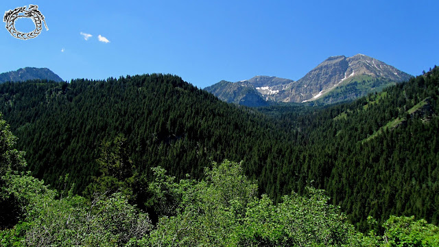
Further up, the road becomes steeper and a lot curvier. You do have to drive cautiously, for the turns are tight, the road becomes narrower, and you may need to give oncoming traffic some room to pass by. A few more miles up this road, and there's a parking place with a gorgeous vantage point of Mount Timpanogos and the surrounding landscapes. This is a good place to stop for a respite, and there are longer hiking paths around this area. In the spring, this might be as far as you can go; snow can remain in the mountains until June or July, so it's possible that the road will be closed from this point onward (the ranger at the shack at the beginning of the park should let you know).

If you are able to continue, you can continue climbing up the mountain in a long and winding length of road. At one point, you'll reach the summit trailhead, where you can stop, park, and take one of several hiking paths branching out to different areas. Some of these paths can be short, just a few miles; others can go on for fourteen miles or so. These paths are usually marked with corresponding numbers and names, and a plaque will inform you as to whether the paths are suitable for hiking, biking, horseback riding, or whatever.
On this trip, I stopped here and took a path that looped around for a few miles or so. The path led me through fields of lush green grass with pockets of colorful flowers everywhere. At times, the path cut through dense groves of aspen trees. It became strenuous with some steep inclines, which eventually led me to a high vantage point where I could see more of the surrounding mountains. It wasn't a long hike, but it was hot, tiring, and satisfying.

Returning to the car, I followed the road again. It continued past the mountains and started to slope downward; I was descending down the other side. There are more rugged views along the way, with some areas to stop if need be. There are more campgrounds to be found. Another ten miles or so, and you'll eventually leave the Uinta National Forest, passing by another booth. From then on, you'll pass by the Sundance ski resort, and a number of more expensive mountain homes. Eventually, the road will end at the US-189 East Provo Canyon Road; you'd turn right to travel out of the canyon and drive into either Provo or Orem. Turning left will lead to the Deer Creek Dam, which I didn't bother visiting this time around (I'm told that there's nothing much to see there, other than to stop for a quick picture or something).
This short adventure only took up a few hours, but it did have some decent scenic views and photo opportunities. Whether venturing out for a quick drive-through, or setting out on an outdoors adventure, the Alpine Loop is good for a short getaway.


Thanks for the tour, Alan. It looks so beautiful there.
ReplyDeleteSo, working to pay off some old debts that keep adding stress and interest. Consistent small losses made everything worse week after week, balance kept shrinking, thought it was hopeless. Upped the stake on spin mama and hit a solid jackpot on Razor Shark. Cleared a big portion of what I owed. Huge relief, sessions remain enjoyable, I'll continue.
ReplyDeleteWollte meiner Freundin zum Geburtstag ein schönes Armband kaufen, aber das Geld hat nicht ganz gereicht. Hab auf verschiedenen Plattformen gezockt und erstmal nur Pech gehabt. Kurz vor dem Aufgeben hab ich den letzten Einsatz verdoppelt und endlich einen Feature-Treffer mit vielen Retriggern gelandet. Die Auszahlung hat das Armband und noch mehr abgedeckt. Spiele jetzt ab und zu auf Spinogambino, weil die Auszahlungen wirklich schnell sind und der Support auf Deutsch hilft. Hat meinen Plan doch noch gerettet.
ReplyDelete